Twin peaks.
Considering the location of the Babylonian Underworld, taking the Epic of Gilgamesh as a guide continue....

And yet Google gives it to me for free: http://www.sacred-texts.com/bib/boe/
The map at the top of this page is from: A Study of the Geography of 1 Enoch 17-19: By Kelley Coblentz Bautch who doesn't (by the way) think that the map is quite right.
The next map comes from the same book and was drawn by Józef Tadeusz Milik.
It looks far more like a Babylonian map which isn't surprising because..

And finally I return to the (Babylonian) Akkadian map:

Reference: http://www.sacred-texts.com/earth/boe/boe10.htm
But find myself none the wiser!
The Mesopotamian 'twin peaks', known as Mashu appear to be the same symbol used by the Egyptians: The Egyptian hieroglyphic sign for "mountain" (djew) and for "horizon" (akhet).
"The mountain of light".
In The Epic of Gilgamesh, Gilgamesh must travel through the passage taken by the sun before the sun enters the passage way. Gilgamesh, being a great hero succeeds, and finds himself in the land at the edge of the world, at the pub beside the sea of death.
The ground is strewn with precious jewels.
It is a strange, desolate and lovely place.
The twin-peak mountains have led to the water.
Gilgamesh can only cross this water in a boat.
No water must touch his skin...for it is instant death!
This triplet of sun, boat and double mountain is portrayed in one of the Egyptian 'books of the dead'. In The Amduaat the setting sun becomes a ship 'The boat of millions'.
The boat crosses over from our world to the sky, between two peaks on a mountain. In this way the twin peaked mountain became for the Egyptians, a symbol of the tomb and the afterlife, and the river of death.
The sun ship carries the dead souls through the twelve hours of darkness. The journey starts well, but soon the tone of the images and descriptions of the landscape in the middle hours become heavier, and in places ominous and full of dread.
The Egyptian symbol for the 'twin peaks' is Djew.
The Egyptians visualized a cosmic mountain range holding up the sky.
This mountain had two peaks, the western peak was called Manu, while the eastern peak was called Bakhu.
When the mountains are with the sun, the symbol becomes Akhet.

It was on these peaks that heaven rested.
Each peak of this mountain chain was guarded by a lion deity (whilst in the Epic of Gilgamesh it is scorpion men)
The Sumerian and Akkadian word denoting mountain (Kur) is an ambiguous symbol.
For the Mesopotamians, Kur was the netherworld and mountains were the border-line between the known and unknown.
For the Sumerians, Kur was a flood, washing all before it. But also Kur was a dragon, guarding the water underground, therefore responsible for floods.

Not really the same thing, but interesting none the less...In 1910 Carl Friedrich Lehmann-Haupt found a rock tunnel two miles long which extends from Bylkalein to the main source of the Tigris river. Physical locations augmented by myth are fascinating locations...shame so many are so far away,In this case, possibly a place called Diyarbakir.
But the image I know best comes from Crowley, who used the Egyptian iconography for his Moon card.
More?

What I was really after was the location of the Twin Peaks of Mashu:
"the great mountain, which guards the rising and setting sun. Its twin peaks are as high as the wall of heaven and its roots reach down to the underworld. At its gate the Scorpions stand guard, half man and half dragon; their glory is terrifying; their stare strikes death into men, their shining halo sweeps the mountains that guard the rising sun" -From The Epic of Gilgamesh.

Sir Walter Raleigh, in his History of the World (written in 1616 while imprisoned in the Tower of London), makes the curious assertion that part of the Book of Enoch "which contained the course of the stars, their names and motions" had been discovered in Saba in the 1st century and was thus available to Origen and Tertullian.The Book of Enoch is one of those books, a liminal book like the Necronomicon, whose existence is more virtual than real, a book one should travel far to find.
Reference Book of Enoch -Wiki.
And yet Google gives it to me for free: http://www.sacred-texts.com/bib/boe/
The map at the top of this page is from: A Study of the Geography of 1 Enoch 17-19: By Kelley Coblentz Bautch who doesn't (by the way) think that the map is quite right.
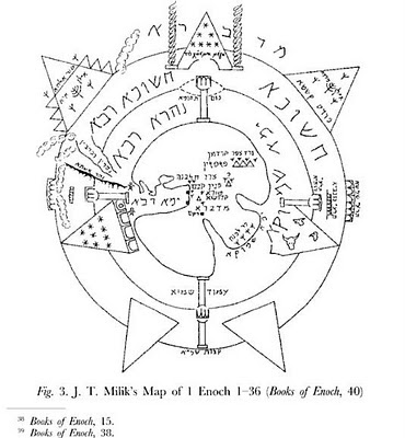
The next map comes from the same book and was drawn by Józef Tadeusz Milik.

It looks far more like a Babylonian map which isn't surprising because..
Józef Tadeusz Milik (Seroczyn, Poland, March 24, 1922 – Paris, January 6, 2006) was a Polish biblical scholar and a former Catholic priest. Fluent in Polish, Russian, Italian, French, German, and English plus many ancient languages Hebrew, Greek, Latin, Aramaic, Syriac, Old Church Slavonic, Arabic, Georgian, Ugaritic, Akkadian, Sumerian, Egyptian, and Hittite.The next map may have been drawn by Kelley Coblentz Bautch:
Reference Józef Milik -Wiki.

And finally I return to the (Babylonian) Akkadian map:

But find myself none the wiser!
Mashu is a great cedar mountain through which the hero-king Gilgamesh passes via a tunnel on his journey to Dilmun after leaving the Cedar Forest, a forest of ten thousand leagues span. The corresponding location in reality has been the topic of speculation, as no confirming evidence has been found. Aaron Shaffer confirmed the reading of the mountain in Sumerian as "Kur Lib-na-nu" through collation of different sources of the Gilgamesh myth.J effrey H. Tigay also suggests that in the earlier Akkadian version it is "explicitly located in the north west, in or near Lebanon".
One theory is that the only location suitable for being called a "cedar land" was the great forest covering Lebanon and western parts of Syria and, in consequence, "Mashu" is the whole of the parallel Lebanon and Anti-Lebanon ranges, with the narrow gap between these mountains constituting the tunnel. The word "Mashu" itself may translate as "two mountains", from the Babylonian for twins.
From Mashu-Wiki.
The Mesopotamian 'twin peaks', known as Mashu appear to be the same symbol used by the Egyptians: The Egyptian hieroglyphic sign for "mountain" (djew) and for "horizon" (akhet).
"The mountain of light".
In The Epic of Gilgamesh, Gilgamesh must travel through the passage taken by the sun before the sun enters the passage way. Gilgamesh, being a great hero succeeds, and finds himself in the land at the edge of the world, at the pub beside the sea of death.
The ground is strewn with precious jewels.
It is a strange, desolate and lovely place.
The twin-peak mountains have led to the water.
Gilgamesh can only cross this water in a boat.
No water must touch his skin...for it is instant death!
This triplet of sun, boat and double mountain is portrayed in one of the Egyptian 'books of the dead'. In The Amduaat the setting sun becomes a ship 'The boat of millions'.
The boat crosses over from our world to the sky, between two peaks on a mountain. In this way the twin peaked mountain became for the Egyptians, a symbol of the tomb and the afterlife, and the river of death.
The sun ship carries the dead souls through the twelve hours of darkness. The journey starts well, but soon the tone of the images and descriptions of the landscape in the middle hours become heavier, and in places ominous and full of dread.
 |
The Egyptians visualized a cosmic mountain range holding up the sky.
This mountain had two peaks, the western peak was called Manu, while the eastern peak was called Bakhu.
When the mountains are with the sun, the symbol becomes Akhet.

It was on these peaks that heaven rested.
Each peak of this mountain chain was guarded by a lion deity (whilst in the Epic of Gilgamesh it is scorpion men)
The Sumerian and Akkadian word denoting mountain (Kur) is an ambiguous symbol.
For the Mesopotamians, Kur was the netherworld and mountains were the border-line between the known and unknown.
For the Sumerians, Kur was a flood, washing all before it. But also Kur was a dragon, guarding the water underground, therefore responsible for floods.
Not really the same thing, but interesting none the less...In 1910 Carl Friedrich Lehmann-Haupt found a rock tunnel two miles long which extends from Bylkalein to the main source of the Tigris river. Physical locations augmented by myth are fascinating locations...shame so many are so far away,In this case, possibly a place called Diyarbakir.
But the image I know best comes from Crowley, who used the Egyptian iconography for his Moon card.
More?


